How to Create a Target Generation Map
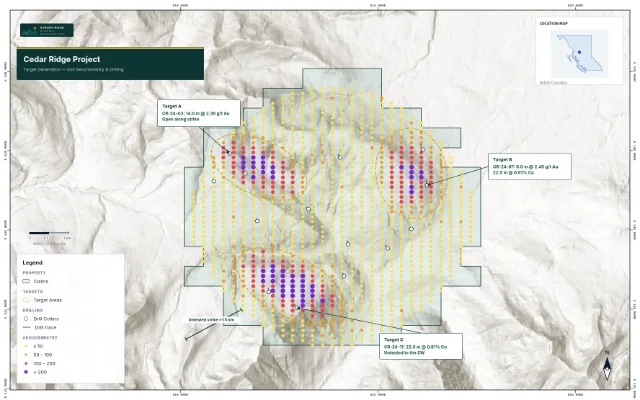
To make a target generation map, import your claims and target outlines, assign the Target Areas role for dashed-outline styling, add drill collars or geochem points if you have them, label each target with a name and one-line rationale, then export. Frame targets as conceptual — they are exploration targets, not resources.
Turn public claim data into a clean map.
No GIS experience needed — import, style, and export in minutes.
Create my map →
What you need
- Claim/property boundary (GeoJSON, Shapefile, or KML)
- Target outlines — drawn in your GIS, or sketched from geophysics/geochem
- Optional: drill collars, geochem points, or geophysical anomaly outlines that support each target
- A one-line rationale per target (e.g. 'coincident IP chargeability + Au-in-soil')
Build the map
- Import the property boundary and assign the Claims role
- Import target outlines and assign the Target Areas role — they get the conventional dashed outline that reads as 'conceptual, not drilled'
- Add supporting layers (collars, soil grids) so targets visibly sit on evidence
- Label each target: short name plus the rationale — 'Target A — IP anomaly, 1.2 g/t Au boulders'
- Choose Satellite or Topographic basemap so targets sit in real terrain context
- Add title block, legend, scale bar, north arrow; export 16:9 PNG for decks or PDF for reports
Styling that reads correctly
| Layer | Convention | Why |
|---|---|---|
| Target areas | Dashed outline, no/low fill | Dashed = interpreted/conceptual; solid fill overstates confidence |
| Claims | Solid boundary, light fill | The one 'hard' legal line on the map |
| Drill collars | Small solid points | Evidence, not the story — keep them quiet |
| Anomalies | Soft colour fill at low opacity | Background support for the targets drawn over them |
Say it safely
Targets are conceptual — label them that way
An exploration target is not a mineral resource. Keep wording like 'exploration target', 'untested anomaly', or 'conceptual' on the map or its caption, and avoid grades/tonnage on target labels unless they carry the required cautionary language. Your QP should review any figure that goes into public disclosure.
Turn your target concepts into a clean map.
Import boundaries, drop in targets, export an investor-ready figure.
Create my map →
Import your file and export an investor-ready map.
Open the editor and have a shareable map in minutes.
Create my map →
Frequently Asked Questions
How do I draw target outlines if I only have points or a grid?
Sketch the outlines in your GIS (QGIS's polygon tool over your geophysics/geochem raster works well), export as GeoJSON, and import. Many teams simply digitize a loose ellipse around the anomaly — the dashed styling correctly communicates that it's interpretive.
What's the difference between a target generation map and a drill plan?
A target map shows where and why you would drill (anomalies, rationale); a drill plan shows exactly where holes are placed. Target maps are conceptual and dashed; drill plans show engineered collar positions.
Can I show geophysics under my targets?
Yes — import anomaly outlines as polygons at low-opacity fill, then draw targets above. Evidence under interpretation is the layout that convinces.
How many targets should one map show?
As many as the property genuinely has — but rank them (A/B/C or 1/2/3) in the labels. A map with 15 unranked targets reads as unfocused; the same 15 with a clear top-3 reads as a pipeline.
Is a target generation map suitable for a news release?
Yes, commonly — but the disclosure caution applies double. Keep target labels free of implied tonnage/grade, mark outlines as conceptual, and have your QP review the figure before release.